
Google DeepMind says its new cyclone model can give forecasters roughly 24 more hours of useful accuracy. The paper supports that headline, but "15 days ahead" does not mean 15 days of equal certainty.
WeatherNext cyclone forecasting moves the useful line by about a day
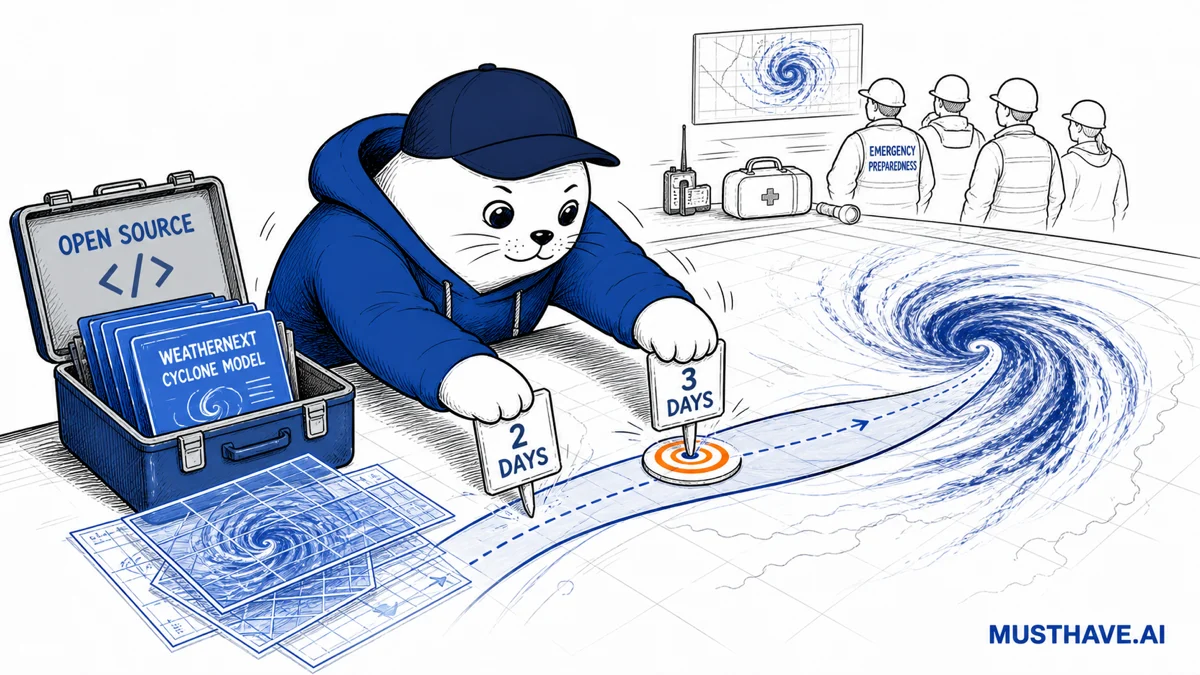
Google DeepMind released WeatherNext Cyclones on August 6 with an unusually concrete claim: on average, its three-day forecasts were as accurate as the two-day forecasts produced by previous leading models. In practical terms, the model shifted a familiar accuracy point about 24 hours earlier.
That result covers three jobs that cyclone models often separate: forecasting the storm’s track, its intensity, and the radii of damaging winds. The accompanying peer-reviewed Nature paper evaluates tropical cyclones from 2023 through 2025 and reports an average lead-time advantage of a day or more over leading operational models.
The number is meaningful because emergency decisions are bought with time. It is also an average from a defined evaluation, not a promise that every basin, storm, forecast cycle, and hazard gets a flawless extra day. A useful reading is "the same error level may arrive about one day sooner." An unsafe reading is "Google can predict any hurricane perfectly three days out."
Evidence check
What the launch supports, and what it does not
Four claims, separated by evidence level.
Peer reviewed
Across 2023–2025 cyclones, the paper reports a day or more of average lead-time advantage for track, intensity, and wind radii.
Published capability
The model can generate up to 1,000 ensemble members and scenarios extending as far as 15 days.
Company report
Google says the system contributed guidance used by the U.S. National Hurricane Center during the 2025 season.
Not supported
The results do not establish perfect forecasts, identical skill at every lead time, or a replacement for official warnings.
The "three days equals two days" comparison is the cleanest result
WeatherNext Cyclones is an ensemble model. Instead of drawing one authoritative line across a map, it produces many plausible future states. Google says a 1,000-member run can turn those scenarios into local probability maps for tropical-storm, hurricane-force, and other wind thresholds.
The Nature paper compares the system with leading operational models on storms that occurred between 2023 and 2025. Its abstract reports that track, intensity, and wind-radii forecasts gained an average of a day or more of lead time. Google translates that into the easier comparison: WeatherNext’s three-day forecast was, on average, as good as what previous models supplied at two days.
Going from two days to three at a comparable error level is a 50% increase in that particular lead-time window: 72 hours instead of 48. That calculation is useful for understanding the size of the shift. It does not mean overall forecast accuracy rose by 50%, and it says nothing by itself about the value of the fourth or tenth day.
Fifteen-day scenarios are not fifteen-day warnings
The model iteratively predicts global weather and fine-scale cyclone behavior up to 15 days in advance. That horizon is valuable for exploring formation risk and the range of plausible tracks. It should not be flattened into a single 15-day forecast.
Uncertainty generally widens with lead time. Early output can tell planners that a region deserves attention; later output can support more specific decisions as observations accumulate. The same page can therefore contain a credible long-range probability and an irresponsible long-range certainty claim.
Use the horizon correctly
From possible storm to public action
Up to 15 days
Explore possibilities
Use ensembles to watch formation risk and broad scenario spread.
Around 3 days
Compare actionable skill
The benchmark shows roughly one extra day at a comparable average error level.
Official warning
Follow human authorities
National agencies combine models, observations, local context, and accountability.
This distinction is not academic. A logistics team might use a long-range ensemble to protect inventory or prepare alternate routes. An evacuation order needs official, location-specific guidance. WeatherNext can improve one input to that process without becoming the authority that issues the warning.
The Hurricane Melissa case shows the intended handoff
Google says WeatherNext guidance was available to the U.S. National Hurricane Center during the 2025 season. In a separate Hurricane Melissa case study, the company reported that the model anticipated rapid intensification and a Jamaica landfall with high confidence five days before impact.
The important word is guidance. The Nature paper includes researchers affiliated with the National Hurricane Center, and it reports that adding WeatherNext Cyclones to a weighted consensus improved that consensus. The model was one forecast source inside an operational process, not a chatbot announcing an evacuation on its own.
That pattern should feel familiar to builders. Our analysis of Reddit’s intent-based moderation reached the same design principle: a probabilistic model can widen detection while a human-controlled consequence remains visible. It also echoes the warning in our Claude workplace overreliance report. Better assistance does not erase responsibility.
Google says the models are open, but check the release you can actually run
Google says it is open-sourcing WeatherNext Cyclones, WeatherNext 2, and a smaller WeatherNext 2-mini model that can run on a single TPU in a free public notebook. That matters because reproducibility is the difference between an impressive chart and a tool a research team can inspect.
There is a timing wrinkle. When we checked the linked Google DeepMind WeatherNext repository shortly after the announcement, the public file index still described GraphCast and GenCast and did not yet expose clearly named WeatherNext Cyclones directories in the crawled view. The repository’s existing code is Apache 2.0, while existing model weights use CC BY-NC-SA 4.0. Do not assume the new artifacts inherit identical terms until their own files and model cards appear.
The practical move is to verify the exact commit, weights, input schema, license, and evaluation scripts before budgeting a deployment. "Open-sourcing now" can describe a rollout that is still propagating across a repository, cloud bucket, notebook, and documentation pages.
Builder preflight
Before WeatherNext touches an operational workflow
01
Pin the release.
Record the repository commit, model weights, license, data version, and notebook used.
02
Reproduce a baseline.
Test held-out storms and a basin that matters to your users, not only the launch examples.
03
Measure calibration.
Check whether 10%, 50%, and 90% probabilities occur at roughly those frequencies.
04
Design failure paths.
Keep official feeds, monitoring, stale-data alarms, and a non-AI fallback.
05
Keep authority explicit.
Label the output as experimental guidance and link users to the responsible weather agency.
A surprising result: coarse inputs did not block high-quality intensity forecasts
Traditional cyclone-intensity systems often lean on very high-resolution regional simulations. WeatherNext Cyclones uses global inputs at roughly 28-kilometer resolution (Google describes them as about 100 times coarser by area than some traditional inputs) yet the paper reports state-of-the-art intensity performance. A smaller model works at about 111-kilometer resolution.
The researchers treat that as an open question, not a solved mystery. Their result suggests that coarser atmospheric fields contain more usable intensity signal than scientists previously recognized, or that the model is extracting historical relationships efficiently. It does not prove resolution no longer matters for every weather problem.
For builders, the appealing part is not merely lower compute. A compact model that runs in an accessible notebook gives universities, public-interest groups, and local forecasters a route to inspect the method. The harder work is validating whether those outputs remain calibrated for the place and decision that matter.
My verdict: treat the extra day as forecast capital
WeatherNext cyclone forecasting clears the bar for important AI news. It has a peer-reviewed evaluation, operational collaborators, a measurable lead-time result, and an open-release path that researchers can test. It is more than a benchmark bump dressed as a product announcement.
The discipline is in how the result gets translated. The model appears to buy roughly one extra day at a comparable average error level. That day is forecast capital: time to prepare resources, run more observations, compare models, and let accountable forecasters narrow the decision. Spending it on false certainty would waste the advance.
If you build with the release, pin the exact artifacts, reproduce the paper’s baseline, measure probabilities rather than admiring tracks, and keep official warnings in charge. The breakthrough is not that a model knows the future. It is that forecasters may get a better distribution of futures sooner.
Go deeper
- Read Google DeepMind’s WeatherNext Cyclones announcement.
- Review the Nature paper, Operational Tropical Cyclone Forecasting with AI.
- Inspect the public WeatherNext repository and verify the files visible in the release you use.
- Check the WeatherNext 2 model page and Google’s model guide.
If an AI forecast buys your team 24 hours, what decision should move first, and what decision must remain with an official forecaster?
Checked August 6, 2026. The benchmark is an average over evaluated cyclones from 2023–2025. Google says the new models are being open-sourced; verify the exact repository artifacts and their licenses before operational use. WeatherNext guidance does not replace alerts from national meteorological agencies.